Wednesday, November 24, 2010

Your path looks boring? Explore the edges!

Everyone's research (or career) path looks like this at one point in time or another.
Whether looking ahead ...

... or in the rearview mirror....
... the path may look flat, predictable, and downright boring. When that happens, there are three choices: continue ahead and hope some exciting breakthrough is waiting around the corner (good luck with that!); change course to a more exciting destination (take the train if needed, to get there faster); or go off the beaten path and explore the edges of your own discipline, and in the process listen to the echoes coming from fields outside your own.  It is the latter that has the potential to bring the biggest breakthroughs.
Happy trails, and remember: it is the journey that counts.

Tuesday, November 23, 2010

Geology field notes - Process to product: ripples

One nice thing about beaches is that you can observe processes and the resulting products  at the same location.  The video clip and the picture were taken from a beach not far away from my home (ok, about an hour drive...).
In the short movie below, the wave action on the beach creates a water flow that entrains the sand and generates moving bed-forms (ripples) on the bed surface.

The resulting rippled bed surface looks like this.
Ripples on a beach                                 ©RomaniaRocks
If the process continues and net sediment accumulation takes place, the result is a ripple-laminated sand.
Enjoy your next walk on the beach and take your own pictures and video-clips of ripples in the making.

Sunday, November 21, 2010

Speleology in Romania - Frasin Aven

Speleology is what got me into geosciences in the first place, therefore a series of posts on caves of all sorts in Romania is in order.
An aven in caving is a very steep or vertical section in a cave that needs ladders or ropes to ascend  and descend. The Frasin Aven (link in Romanian) is located in the Obcina Mare Mountains, which are part of the Eastern Carpathians mountain range.

The Frasin Aven is the northern-most pin on this map; zoom out for better viewing.  Locations of other caves in Romania are also indicated on the map.
View Romanian caves in a larger map


The Frasin Aven can be accessed from Frasin village, on the National Highway #71, between Gura Humorului and Campulung Moldovenesc. The aven was discovered in 1975, it has an elevation change of 73.2 meters, which placed it in the 20th place in the world for elevation change for sandstone caves (based on 1989 statistics).
Frasin Aven sketch, after Giurgiu and Muraru, 1977
From a geologic point of view, the aven is located in the Carpathian Fold and Thrust Belt (Tarcau Nappe), and it is developed in Kliwa Sandstone Formation (Oligocene in age). Kliwa is a deep-water siliceous sandstone (98% silica content), and the aven is thought to have formed within a fracture caused either by extension associated with its position on a crest of an anticline, or via detachment and sliding of the sandstone block along its basal contact (the Kliwa Formation consists of a succession of interbedded sandstone and mudstone).

Wednesday, November 17, 2010

Seismic geomorphology research conference


If you are in or near Houston-Texas, or can get to Houston in early December, I highly recommend this: the 30th Annual GCSSEPM Foundation Bob F. Perkins Research Conference - "Seismic imaging of depositional and geomorphic systems".  With a 3-day full program, the BEG visualization center set up for people to view data volumes, and keynote speakers such as Kurt Marfurt, Sergey Fomel, Henry Posamentier, this will be THE conference on this topic for years to come.
The conference will be held at the Houston Marriott Westchase,  on December 5-8, 2010.  You may register for the event here.
The conference will cover the entire spectrum of depositional systems, clastics and carbonates, a wide variety of geographical locations, basins and geological settings: incised valleys on the Sunda Shelf, Indonesia; carbonate platform systems in the Browse Basin, Australia; estuarine deposits in the Gulf of Cambay, India; Pleistocene turbidites from NE Nigeria; point-bars in the McMurray Formation, Canada; channel-levee complexes, slope valleys and canyons from East Kalimantan, Indonesia; and much more.
I will be sharing on Twitter and blogging from the conference (hopefully).

Sunday, November 7, 2010

Fluvial and aeolian rocks from the Triassic of Utah

Rocks are like people...in some ways. You take the same "material" (be it genetic for people, sedimentary for rocks) and place it in different environments, and you will get different results.
©RomaniaRocks
One of the principal goals in sedimentary geology is to identify the environment of deposition by looking at rocks and their characteristics.  It is very important to be able to determine if a package of rocks was formed by wave processes pounding on a beach, by river processes, or by gravity flows traveling from submarine canyons to the abyssal plain of oceans.  It is important because by doing so, we can understand, for example, past climate (and use it to predict future climate), we can understand the Earth complex systems, we are able to make predictions about the presence (or absence) at a certain location of a certain rock type, etc.
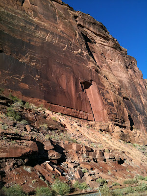
This post shows an example  of the difference between fluvial and eolian rocks.  Both pictures (above and below) show the eolian Wingate Sandstone, overlying the fluvial Chinle Formation.
©RomaniaRocks
The Wingate Sandstone forms the steep, upper pat of the cliff. It is called an aeolian sandstone because it was deposited by the action of the wind in a desert environment, not unlike what the Sahara desert is today.  
The Chinle Formation can be seen immediately below the Windgate, it is more heterogeneous from the point of view of the lithology, consisting of mudstone, sandstone and conglomerate.  The Chinle was deposited by rivers flowing on a floodplain.

Immediately after hitting the "Publish post " button I saw "Where does desert sand come from?" talking about the Namib Sand Sea, and posted on the AGU blogosphere site by Vivienne.  An appropriate present day analogy for the Wingate of the Triassic.

Enhanced by Zemanta

Monday, November 1, 2010

Geology field notes - Mud cracks

©RomaniaRocks

When muddy sediment is exposed to the atmosphere and dries up it commonly develops polygonal shape cracks in plan view, V-shaped in cross section.

Monday, October 4, 2010

Landscapes into Rock - Part 4

This post ends my summary of the Landscapes into Rock conference that took place in London, September 21-23, 2010.  Click here for previous posts.

Theme three – Landscapes into Rock – was obviously the central theme of the Conference. It was chaired by Sebastien Castelltort (ETH – Zurich) and Emma Finch (University of Manchester), it had eleven oral presentations and featured a very insightful “keynote of the keynotes” by Mike Leeder (University of East Anglia). Of interest for me was the research by Alex Whittaker et al using regional grain-size trends to derive information on the dynamics of the sediment routing system.

The high-point of the session was the keynote address by Mike Leeder. Mike put forth many interesting and provocative ideas:

  • the need to fully utilize the sedimentary record to test the landscape evolution models; 
  • the recent advances in speleothem and calcisol research that may provide the ability to isolate climate/vegetation forcing of the eroding landscape; 
  • the understanding of the link between the rate of tectonic evolution and how they induce major changes in the landscape; 
  • teleconection – the link between the eroding landscape and the downslope deposcape.

The fourth (and last) theme – Integrative studies of sediment routing systems and the petroleum systems - was organized by Ian Lunt (Statoil) and Mike Blum (ExxonMobil), and featured two presentation and two keynote speakers – Ole Martinsen (Statoil) and Peter Burgess (Shell and Royal Holloway University of London). For me, the highlight of this session was Peter’s overview of stratigraphic forward modeling in hydrocarbon exploration. Peter noted that stratigraphic forward models (SFM) are more mature but still have a limited predictive power. SFM prove most useful in their ability to quickly create multiple scenarios, to test hypotheses and ideas, to devise numerical experiments that illustrate how depositional systems work and through that to develop new plays and concepts.

On a less-formal side, the conference ended each day with a social hour, which involved a lot of discussion of the ideas presented during the day, accompanied by wine, of course.  The discussions were less formal, but certainly not less technical.  They were less flashy than the gathering that took place at Dolce & Gabbana one evening, just down the street from the Burlington House (picture below), but the social hour at the Landscapes into Rock conference were certainly more intellectually stimulating -- for me :)

Related Posts Plugin for WordPress, Blogger...