
Sunday, June 6, 2010
Trip to the Mesozoic
This summer we are going to Romania to visit family and friends and are planning a trip to the Piatra Craiului Mountains. We will spend at least a couple of days hiking the Mesozoic reef buildups in the area, and will enjoy some of the most amazing scenery in the Southern Carpathians. Our first excursion will most likely be on the Northern side of the mountains, from the town of Zarnesti (link in Romanian) to Turnu and Padina Popii Peaks via Padina Hotarului. A fun hike with about 1200m of elevation gain.

Sunday, May 23, 2010
The invisible oil spill
I am a geoscientist and the Earth is not only my home, but also my passion and my profession. The oil spill in the Gulf of Mexico saddens and troubles me deeply. Much has been talked, published and blogged about it, so I will not discuss it here. Instead, I would like to talk about the "invisible oil spill", which is happening every day, ever since oil was discovered. This is the oil that you and I consume daily, and in every way it is the fundamental reason we have an oil spill in the Gulf today. Bare with me through this simple calculation.
I drive to work about 20 days every month (some days I bike to work), which makes about 240 days/year. My car gets about 25mi/gal. If, on average, one barrel of crude yields 19.5 gallons of gasoline, and if my math is correct, in 16.25 days my car consumes one barrel of crude just by driving to work, and every year I use 14.8 bbl of oil, just to drive to work. Another way to look at this - I "spill" about 15 gallons every year just by driving my car to work - an invisible spill, but one that is real.
The US oil consumption is estimated at about 19 million barrels/day, so WE collectively "spill" millions of barrels every day. This is a complex issue; petroleum (and coal) fuel the world's economy, and through that, contributed to the progress of the human civilization as we know it. We humans, collectively, have the responsibility to find a sustainable path that will take the civilization forward and be sensitive to the planet in the same time. The blame game is never very effective. One cannot point fingers and roll up the sleeves in the same time.
Sunday, April 18, 2010
Volcanoes -- modern and ancient
The recent eruption of the Eyjafjallajökull Volcano in Iceland made a lot of press lately and captured the interest of scientists and non-technical folks alike. In this post I want to compare and contrast the modern volcanism in Iceland with the Neogene-Quaternary volcanic setting in Romania and, in doing so, to briefly review two different tectonic settings in which volcanic activity may take place.
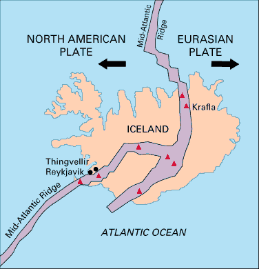


Iceland is located at a divergent plate boundary over the Mid-Atlantic Ridge, along which the North American Plate and Eurasian Plate are being pushed apart by newly formed crust (diagram below from USGS Credit: U.S. Geological Survey Department of the Interior/USGS)
A deep-seated mantle plume is also present in the area and interacts with the North American Plate. This plume (or hotspot) and the active spreading axes are producing the volcanism of present day Iceland. The map below (from R.G. Trønnes, Nordic volcanological Institute, University of Iceland) shows both the active and old spreading axes as well as the position of the mantle plume between present day and 40 million years ago.

The ash cloud from the icelandic volcanic eruption was observed in the Northern part of Romania on April 16 and 17, but Romania had ash produced from its own volcanoes as recently as 10,000 years ago. In contrast to Iceland, the Romanian volcanoes were active at a convergent plate margin. The resulting volcanic arc deposits are Neogene to Quaternary in age and are located in the Northern part of the Eastern Carpathian mountains. The map below (from A. Szakracs,I. Seghedi, 1995) shows the volcanic cones and the associated deposits in Calimani-Gurghiu-Hargita mountains.

The Eastern Carpathians volcanic arc is 160km long, the longest in the entire Carpathian mountain belt. It formed as a result of the convergence between two plate fragments, the Transylvanian micro-plate and the Eurasian plate. The volcanic activity spanned from ~15 Ma to 0.01 Ma ago. The area is interesting not only from the geological point of view, but also for its natural beauty, but about this in another post.
Wednesday, April 14, 2010
Free books and ... geology of course
I was driving back home from the office today listening to NPR, and Andrei Codrescu's commentary "Getting From Here to There" inspired me in many ways. His story also pointed me to an iPhone app "FreeBooks", which I immediately searched for and downloaded when I arrived home. The app is advertised as "23,469 classics for less than a cup of coffee" and I can tell that it will become one of my favorite apps. It will take me a while to read all of this good stuff, but for sure among the first will be the "geology-flavored" books. Here are some of them, now accessible anytime from my trusty iPhone (if I would only have more than 24h in a day):
- The Student's Elements of Geology - by Charles Lyell (1870)
- Geological Observations on South America - by Charles Darwin (1846)
- Geological Observations of Volcanic Islands - by Charles Darwin (1844)
- Geological Contemporaneity and Persistent Types of life - by Thomas H. Huxley (1862)
- The Economic Aspects of Geology - by C.K. Leith (1921)
- Discourses: Biological and Geological Essays - by Thomas Henry Huxley (1894)
- Town Geology - by Charles Kingsley (1871)
- The Boy Scouts of the Geological Survey - by Robert Shaler
So, drink one less cup of coffee, relax with a good ole book and be happy!
Thursday, April 8, 2010
Geoscience metaphors (or geo-puns) #2 - "Rock solid"
Oh! parent, parent! send no son to California except he be rock-solid adamant to all vice. Be her mountains pure gold, let them stand; send no kith or kin of thine to dig them, nor thyself turn towards them, unless armed like an old knight, cap-a-pie, for a desperate conflict, not with revolver and bowie knife, -lead and steel are of small worth, - but with manly principle, a moral coat of mail, light and easy, but impervious.This is the oldest reference I could find of rock-solid being used as a geoscience metaphor. It is an excerpt from the letter "Straws from the Gold Coast" written on June 26, 1849 in San Francisco and published in the "Daily Southern Cross". The article also offers an interesting account of what San Francisco was like not even one year after the official start of the Gold Rush:

A timeline from Google News Archive for this geo-pun looks like this:

just follow the link above and chose your favorite rock-solid reference.
In a more recent reference of this metaphor, Joshua Greenman describes his iPad experience with the words "Zippy web browsing, rock-solid feel: New Apple iPad is perfect down to the last micrometer".
One of most famous Romanian rock-solid geo-puns is "tare ca piatra, iute ca sageata", translated as "rock solid and fast as the arrow"; it is part of an ancient Romanian New Year's custom, when kids go around with a stick adorned with flowers and wish the loved ones all the best in the new year. One can find more info on this custom, which is known as "Sorcova", here.
Sunday, March 28, 2010
Geology and wine #4 - Wine and Earthquakes
Some of the oldest wine growing regions in Romania are in Vrancea, an area also known for the highest seismicity in Romania. The red ellipse on the image below shows where Vrancea is located: within a structurally complex area named in Romanian "zona de curbura" literally translated as the "bend zone", because the Carpathian arch bends as it transitions from the Eastern Carpathians to the Southern Carpathians.
I'll start with the earthquakes, so that my post will have a happy ending, on the topic of wine.
Vrancea is a subduction zone and the widely accepted model for the seismicity is shown in the E-W cross section below (sourced from the Romanian earthquake forum, Cutremur.net):
 It is postulated that a slab from the plunging plate detached about 10 million years ago and its motion, as it sinks and is consumed in the mantle, generates quakes. The depth range for the hypocenters varies between 15 and 220 km. Areas to the NE or SW of Vrancea are the most affected during an earthquake, which is why Bucharest is the number two European capital with the highest seismicity (after Lisbon). I went through a 7.4 earthquake in Bucharest in 1977, and it was not fun (I wasn't even a geologist yet at the time, to at least find "pleasure" in the scientific aspect of the event). More on Vrancea quakes here and here.
As for the wine, the best known wine regions in Vrancea are Panciu, Odobesti and Cotesti. The best wines from native grapes here are the Feteasca Regala, Tamaiosa Romaneasca and Feteasca Neagra. The last is my favorite, with its bouquet of blackberries and dried plums, and a hint of bitterness as it gets more mature.
I'll start with the earthquakes, so that my post will have a happy ending, on the topic of wine.

Vrancea is a subduction zone and the widely accepted model for the seismicity is shown in the E-W cross section below (sourced from the Romanian earthquake forum, Cutremur.net):

As for the wine, the best known wine regions in Vrancea are Panciu, Odobesti and Cotesti. The best wines from native grapes here are the Feteasca Regala, Tamaiosa Romaneasca and Feteasca Neagra. The last is my favorite, with its bouquet of blackberries and dried plums, and a hint of bitterness as it gets more mature.
Saturday, March 27, 2010
Depositional facies models - the need to move on?
I am reading John S. Bridge's River and Floodplains, which I highly recommend for anyone interested in fluvial processes and the resulting deposits. His comments on depositional facies models deeply resonate with me:

This was a fun exchange, unfortunately for me it was so late in the day, and the 140 character limitation was not helping.
There is a solution to this problem, and I will cite again from Bridge, because he expressed it so well:
Most facies-association models in the literature are inadequate for anything more than a very general qualitative environmental interpretation because: (i) the deposits are normally represented in only one or two vertical sections, normal and parallel to the flow direction; (ii) the information shown in these two-dimensional sections lacks critical detail of the spatial variation of strata thickness and orientation, grain size, internal structures, paleocurrents, and biological features; (iii) the nature of preservation of the strata is not indicated, because the models are not dynamic; and (iv) the models are purely qualitative and many do not even contain scales. The reasons for this state of affairs are: (i) incomplete knowledge of depositional environments (ii) incomplete knowledge of the evolution of depositional environments and their deposits over time periods in excess of a few hundred years; and (iii) uncertainties in translating essentially two-dimensional (parallel to land surface) information representing a single snapshot in time into a fully three-dimensional dynamic model.I really agree with Bridge's comments and strongly believe that the principal focus on descriptive and qualitative, amplified by the proliferation of conceptual models in sedimentary geology was and is detrimental to the advancement of the science. Which reminds me of a Twitter exchange I had with @clasticdetritus a while ago. It started from my venting over how overwhelmingly descriptive and qualitative sedimentary geology is, and how beneficial would be to have a much stronger link between designing (quantitative) experiments to test concepts. The Twitter thread is shown below, in "proper stratigraphic order", with the newest comment at the top.

This was a fun exchange, unfortunately for me it was so late in the day, and the 140 character limitation was not helping.
There is a solution to this problem, and I will cite again from Bridge, because he expressed it so well:
The solution to these problems require much more serious, comprehensive studies of modern processes and deposits, supplemented by scale-model experimentation and quantitative theoretical modelingWhat are your thoughts on this?
Subscribe to:
Comments (Atom)